The proposed site is being nominated for both the exceptional blanket bog and the biodiversity (bird and plant life) it contains. The drafting of the proposed site boundary has been led by scientists at the Environmental Research Institute (part of the University of the Highlands and Islands) in Thurso and NatureScot. the revised boundary takes into account the feedback which was received through the in-person and online consultation that was carried out during mid-2022. Representations were made for both expanding and contracting the proposed boundary. A report detailing the consultation feedback and the consideration given to the points raised has been released and can be found here.
Proposed Flow Country World Heritage Site Boundary
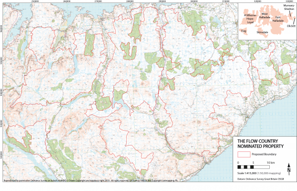
Boundary Rationale:
The rationale for the boundaries is that they contain areas of the blanket bog landscape in the most natural condition, the majority of which is contained within SSSIs and other designations.
The boundary also includes areas adjacent to the blanket bog landscape that are functionally important, and provide protection, to the properties values.
This will include areas that are otherwise surrounded by blanket bog and form part of the blanket bog landscape.
Areas under restoration [or with potential to be restored] will also be included in the property as there is sufficient evidence to suggest that over time they would be on a trajectory towards functional blanket bog, except where there is additional infrastructure in place.
Documentation
Higher resolution version of the draft boundary map
Nominated Flow Country World Heritage site boundary GIS shape files
Nominated Flow Country World Heritage site boundary GIS shape files licence note
Draft Management Plan for the nominated Flow Country World Heritage site (incl. summary description and justification)
[please note: the Draft Management Plan was produced prior to the release of NPF 4 and will therefore be updated prior to adoption, should inscription be achieved]